Special Program for International Students
GRADUATE COURSE IN EARTH SCIENCE
& GEOENVIRONMENTAL SCIENCE
Current students


Ibrahim Danlami Mohammed (Nigeria)
Email: danlami.ibrahim@yahoo.com
Thesis title: Evaluation of Present Lake Environment from Geochemistry of Bottom Sediment of Hartbeespoort Dam, North-West Province, South Africa.
Supervisor: Professor Hiroaki Ishiga (2016-2018).
1.0 INTRODUCTION
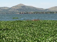
Hartbeespoort Dam is an artificial lake located about 40km west of Pretoria in a valley between the Daspoort Hills and the Magaliesberg mountains. The major tributaries that supply water to the lake are Crocodile and Magalies river, which drains industrial and urban district of Johannesburg and agricultural areas in the country side respectively. (DWA, 2009). The Lake is one of the famous tourist destinations in the North West Province; its environment has been subjected to pollution recently due to industrial and residential growth around the Lake and its catchments. Excessive inflow of nutrient and other pollutants from anthropogenic sources into the lake are responsible for the unwanted algal and water hyacinth blooms on the water surface.
Sediments records historical events in the environment and offer vital information about heavy metal accumulation which could be from anthropogenic or geogenic (natural) source. (Glasby et al., 2004). Enriched Metals trapped within the sediment can be reintroduced into the aquatic system in a bio-available form through remobilization processes (Gambrell et al., 1991). These can pose direct threat to aquatic lives and humans. This research is aimed at evaluating the environment condition of the lake using bottom sediment.
2.0 GEOLOGY OF THE AREA
The study area is build up by the rocks of the Pretoria group which belongs to a stratigraphic unit called the Transvaal Supergroup. The Pretoria group consist of quartzite ridges which dominate the morphology of the area. The shales were eroded to form the valley between the rugged ridges of quartzite and host the Hartbeespoort Lake (Du Toit, 1954).
3.0 Methodology
3.1 Sampling
Bottom sediment samples were taking in March, 2017. A total of 10 samples were collected across the entire lake using dredging method with the aid of a boat. The depth of the sampling stations ranges between 7 and 22m. The samples were packaged in polyethylene bags and transported to Shimane University Japan for XRF analysis.
REFERENCES
Department of water affaires (DWA). 2009. About the Hartbeespoort Dam. http://www.dwaf.gov.za/Harties.
Du toit, A.L. 1954. The Geology of South Africa. Oliver and Boyd, London.
Gambrell R, Wiesepape J, Patrick W and Duff M (1991). The effects of pH, redox, and salinity on metal release from a contaminated sediment, Water, Air, and Soil Pollution, 57-58: 359-367.
Glasby, G. P., Szefer, P., Geldon, J., and Warzocha, J. (2004).
Heavy-metal pollution of sediments from Szczecin Lagoon and the Gdansk Basin, Poland. Science of the Total Environment, 330(1–3), 249–269.
http://dx.doi.org/10.1016/j.scitotenv.2004.04.004.
