Special Program for International Students
GRADUATE COURSE IN EARTH SCIENCE
& GEOENVIRONMENTAL SCIENCE
Current MEXT students
Wendi Harjupa (Indonesia)
Email: wendiharjupa @yahoo.com, wendi @rslab.riko.shimane-u.ac.jp
Thesis title: Study on Orographic Rain System Base on X Band Rain Radar.
Supervisor: Prof. Toshiaki Kozu (2011-2012).
West Sumatra is located in the western part of Sumatra Island, Indonesia. This region directly faces the Indian Ocean. West Sumatra has a complex topography which includes mountainous areas, particularly in the area near Bukit Barisan. Heavy rain frequently occurs in the area. Some studies have suggested these extreme weather events are caused by orographic rainfall, where voluminous precipitation is produced by blockage of air masses by the mountains. These heavy rainfalls have often caused disasters such as landslides and floods.
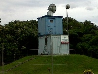
In my study, I will determine the behavior of heavy orographic rain in West Sumatra. I will use data from the X-Band Rain Radar that is installed at Kototabang in West Sumatra. The X-Band Rain Radar collects the distribution of rain in an area 120 km in diameter. The RHI (Range Height Indicator) from X-Band Rain Radar is used to determine the height of cloud. The Equatorial Atmosphere Radar (EAR), a 47-MHz wind profiler, is used for measuring altitude profiles of wind velocities. Wind information provided by the EAR is used to interpret the rain field measured by the X-Band Rain Radar.
During my study at Shimane, I will collaborate with researchers from BPPT (The Agency For the Assessment and Application Technology) and BMKG (Meteorology, Climatology and Geophysics Agency). BPPT and BMKG operate weather radar in Sumatra. They need input from researchers who are skilled in remote sensing, and who can analyze their data to determine rain characteristic over Sumatra. This observation data will be used at my division in LAPAN (National Institute of Aeronautics and Space) to increase our capability in modeling, and to make weather forecasts in the mountainous regions in Sumatra. These forecasts are very important for disaster prevention, so the local population can avoid disasters such as floods and landslides.


